
Comparison / Reviewed
Best off-road apps UAE.
Choose for your drive.
Navra, Gaia GPS, OsmAnd and Wikiloc each solve a different part of off-road navigation. Start with the job you need done, then compare the offline maps, routes and group tools for dunes, wadis and mountain trips.
The direct answer
Your route. Your crew.
Your 4x4.
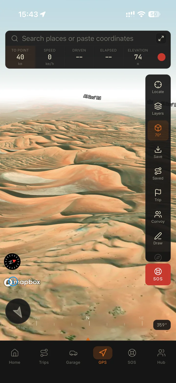
Choose Navra if you want navigation, trips, convoys and vehicle records together around UAE off-roading, on your phone and on the web. Choose Gaia for map layers, OsmAnd for map and GPX configuration, or Wikiloc for finding community trails. All four support iPhone/iOS and Android.
Job by job
Which app
for which job.
The jobs UAE drivers actually have, and the app that does each one best. Where a global tool is the better fit, it says so. On a smaller screen, scroll across to read each row.
| The job | Best fit | Why |
|---|---|---|
| Plan a route on a big screen | Navra on the web, or Gaia GPS on gaiagps.com | The Navra web app draws routes that follow the roads or cut straight across the sand, shows the climb and drive time, and syncs to the phone on the same account. Gaia GPS also plans in the browser and is the stronger choice when you want to compare many map layers while you plan. Navra on the web |
| Follow a GPX track with no signal | Navra or OsmAnd | Import the GPX and download the map area before you leave coverage. In Navra, GPX import is in the free app and offline map downloads come with Navra Pro. OsmAnd suits drivers who want detailed control over tracks and map styles; check its download options for your phone and plan. Import a GPX route |
| Find community trails abroad | Wikiloc | Its library of trails shared by other outdoor users is the better place to look for ideas outside the UAE. Check each trail for age, vehicle suitability and current access before you follow it. Navra does not run a public map or directory of trails or spots, so it is not the tool for this job. |
| Layer several map sources | Gaia GPS | Choosing and layering map sources is what Gaia GPS is built around. Confirm that each layer you rely on actually covers your UAE route. |
| Run a convoy with live positions | Navra | Drivers join a live convoy free from the phone; check hosting availability in the app. While you share your position in the convoy from your phone, you can also follow the group on a laptop in the live control room on the web, which is watch only. Live positions need a data connection on the sharing phone. The live control room |
| Keep vehicle and service records | Navra | The garage keeps specifications, modifications, documents and service history with the vehicle, and Navra Pro adds OBD-II diagnostics with a compatible Bluetooth adapter. Garage and OBD-II |
| Bring your Google Maps pins across | Navra | The free converter on navra.ae turns a Google Takeout export into GPX waypoints inside your browser, with nothing uploaded, ready for the Navra web library or the phone. The result is a standard GPX file, so Gaia GPS and OsmAnd can import it too. Google Maps saved places |
| Keep your location private | Navra, and check any app yourself | The Navra app has no ads and no third-party trackers, and we do not sell data. Your live position goes only to the convoy or friends you choose, and Navra does not run a public map or directory of desert spots. Whatever you use, read its store data labels and privacy policy before you share a position. Your data in Navra |
Four apps, different strengths
Compare the tools.
Match your route.
Feature availability depends on the plan and downloaded area. On a smaller screen, scroll across to compare all four apps.
| Your need | Ventrax Navra | Gaia GPS | OsmAnd | Wikiloc |
|---|---|---|---|---|
| Strongest reason to choose it | UAE trips, navigation, convoys and your vehicle garage together. | Layered outdoor maps and selecting different map sources. | Customisable offline maps and detailed track management. | Discovering and following community-published trails. |
| Mobile platforms | iPhone and Android, available now. | iOS and Android. | iOS and Android. | iPhone and Android. |
| Offline maps | Download map areas with Navra Pro before the drive. | Map downloads require a subscription; select sources and resolution. | Downloadable vector maps; free and paid options vary by platform and plan. | Free offline maps; following saved trails with navigation aids requires Premium. |
| Routes and waypoints | GPX import, waypoints and trail recording; custom route drawing (check in-app availability). | Import GPX routes, tracks and waypoints into your Gaia account. | Import, record, edit and organise GPX tracks and waypoints. | Search and save community trails, record your own, or use its Premium route planner. |
| Terrain and map detail | Satellite maps, plus terrain and 3D views with Pro. | Worldwide Gaia Topo; additional layers have different geographic coverage. | Configurable map styles; topography options include contours, terrain and offline 3D relief. | Offline outdoor maps with elevation information and trail context. |
| What to check for a UAE drive | Download the exact area; live convoy updates require a connection. | Confirm each chosen map layer covers your UAE route. | Prepare the map, GPX track and any additional terrain data you need. | Check trail age, vehicle suitability and current access before following it. |
Selection notes and official sources
What suits you.
And why.
Gaia GPS, OsmAnd and Wikiloc sources checked on . Plans and map coverage can change; use the linked publisher documentation when making your choice.
Ventrax Navra
Choose Navra when you want one place for UAE route preparation, the crew and your 4x4, on your phone and on the web. Navra Pro adds offline maps, terrain and 3D maps, plus OBD-II tools with a compatible Bluetooth adapter. Joining a live convoy is free; check hosting and route-drawing availability in the app. Live location updates need a connection.
Gaia GPS
Choose Gaia GPS when comparing and layering map sources is central to your planning. Its offline downloads let you choose sources and resolution. Check coverage: worldwide Gaia Topo does not mean every specialist map layer covers the UAE.
OsmAnd
Choose OsmAnd for control over map appearance and a detailed GPX workflow. You can organise track folders, edit routes and configure terrain data. That depth rewards preparation; check the feature and download entitlements for your phone and plan.
Wikiloc
Choose Wikiloc to discover routes shared by other outdoor users. It offers free offline maps, while Premium adds trail navigation, a route planner and live tracking. Its live tracking also needs internet. A published track gives you an idea to assess, rather than proof that a route suits your vehicle or today’s conditions.
Where Navra is different
More than a map.
Here is what that means.
What sets Navra apart for UAE drivers, each with the page that explains how it works.
Plan on the web
The companion web app at app.navra.ae has a route planner that follows roads or cuts across the sand, and a GPX, KML and KMZ library. You can plan and size an offline map area on the big screen, then download that area in the Navra app on your phone. Same account, same routes, on a screen that fits them.
Navra on the web →Google Maps pins, brought across
Export your saved places with Google Takeout and convert them to GPX waypoints on navra.ae. The conversion runs in your browser and the files are never sent to us.
Import Google Maps saved places →A live control room
While you share your position in a convoy from your phone, you can follow the same convoy on a big map from a laptop, with the roster beside it. The web view is watch only: it shows the positions drivers share from their phones and never shares one of its own.
The live convoy control room →A garage for each 4x4
Specifications, modifications, documents and service history stay with the vehicle they belong to. Navra Pro also reads OBD-II data through a compatible Bluetooth adapter; available data varies by vehicle.
Garage and OBD-II →A stand on privacy
The Navra app has no ads and no third-party trackers, and we do not sell data. Navra does not run a public map or directory of desert spots. You choose who sees each trip: only the people you invite, one of your groups, or the Navra community. The places people drive stay theirs.
Your data in Navra →People you can reach
Navra is built and run by Ventrax Digital, a registered Dubai company. Call or WhatsApp 058 521 0365, or email [email protected], and a person replies.
Contact Ventrax →Fit check
Start with
what you need.
Navra is a strong fit if
- You organise or join UAE off-road trips and convoys.
- You want your route, trip and vehicle information together.
- You use an iPhone or Android phone, and want to plan on a big screen too.
- You want offline downloads and advanced mapping with Navra Pro.
- You want your live position shared only with the convoy or friends you choose.
Consider the alternatives if
- You want to layer several specialised map sources: look at Gaia GPS.
- You want deep map customisation and track management: look at OsmAnd.
- You want to browse a large community trail library: look at Wikiloc.
- Your route needs a particular map layer or device workflow: verify it before choosing.
Direct answers
Comparison FAQ
Which off-road navigation app should I use in the UAE?
Choose Navra for an integrated UAE trip, convoy and vehicle workflow; Gaia GPS for layered map planning; OsmAnd for configurable offline maps and GPX management; or Wikiloc for community trail discovery. The best fit depends on your route, map coverage and preferred workflow.
Is Navra available on iPhone and Android?
Yes. Ventrax Navra is available on the App Store for iPhone and on Google Play for Android. The same account also works in the companion web app at app.navra.ae for planning routes, managing GPX files and watching a live convoy.
Can I use Navra without a mobile signal?
Navra Pro lets you download map areas before leaving coverage. GPS positioning can work without mobile data, but live convoy positions and location sharing require a connection. An offline map does not provide offline live tracking.
Which off-road app is best for beginners and families in the UAE?
Start with whichever app your convoy leader uses, because driving with experienced people matters more than the app. Navra is rated for all ages, lets anyone join a live convoy for free and keeps the meeting point, route and emergency contacts in one place. Our families guide walks through a first dune drive step by step. Whatever you choose, download the map area before you leave the tarmac and never drive the desert alone.
Do I need Navra Pro to join a live convoy?
Joining a live convoy hosted by another driver is free. Check hosting and route-drawing availability in the app. Navra Pro includes offline map downloads, terrain and 3D views, plus OBD-II tools with a compatible Bluetooth adapter. Live position updates require an internet connection.
On iPhone, Android and the web
Prepare your
next UAE drive.
Start with the route and the people joining you. Download the area you need before leaving coverage.